Cornell University Library Digital Collections
Southeast Asia Visions
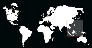
Geographic context
The concept of Southeast Asia as a region began during World War II. It is a strategic definition that is still used by the region's leaders in the Association of Southeast Asian Nations (ASEAN). This strategic area was conceived as extending from eastern India and southwest China to the northern shore of Australia, then along the eastern face of the Philippines. Included in the region are the nations of Brunei Darussalam, Cambodia, East Timor, Indonesia, Laos, Malaysia, Myanmar, Philippines, Singapore, Thailand, and Vietnam.


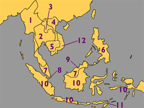
Area of detail, Southeast Asia: 1. Burma; 2. Thailand; 3. Laos; 4. Vietnam; 5. Cambodia; 6. Philippines; 7. Malaysia; 8. Singapore; 9. Brunei; 10. Indonesia; 11. East Timor; 12. Indochina (shaded region)
For more information on maps of Southeast Asia, contact the Maps and Geospatial Information Collection at Cornell University Library.
NOTE: This is a modern political map of Southeast Asia (with the exception of Indochina, which is a historical political unit previously occupied by the French). Please be aware that these political boundaries have shifted over time.

